Sunday, January 25, 2015

South Coast Track

DAY 5

Melaleuca - Point Eric

I was soooooo glad that I came all the way to Melaleuca the night before... it absolutely pissed down!  But I was snug as an insect of the order Hemiptera in a thick woolen floor-mat, just listening to it pelt down and feeling sorry for whoever was out there.  My roommate Rick took off for the South Coast track early despite the continuing rain.  Me, I just chilled.  Had gourmet delight for breakfast, stretched, waited, chatted with the rangers and then eventually left at about lunchtime.


The lagoon before Cox Bight... or as it should be known, Bight Cox.

Thankfully the first section of track was mostly boardwalk, and even though half of that was underwater, it was nice not to have to stress so much about where to put one's feet.  I met Hugh & Dan from Hobart who'd just taken an overnight trip to New Harbour on the South-West Cape track.  They said it was great.

You can see the track winding down to the lagoon behind the dunes.  It was great to see the surf.  I made it to Point Eric camp by mid-afternoon and enjoyed a leisurely afternoon.  Rick was already there and Hugh & Dan joined us later that eve.  Rick was using tent and tarp made from Cuben Fibre - ultralight, strong and waterproof.


DAY 6

Point Eric - Little Deadman's Bay

Don't try this at home, kids. Epic day.

I woke, packed and set out early.  The going was pretty good actually.  It was a pretty good mix of beach and rainforest and buttongrass peat so it kept things interesting.  The South Coast track is certainly spectacular - I can see why so many people do it compare to the Port Davey track.

After smashing it up the Red Point Hills, there was a gentle descent to the first in a series of creek crossings.  The book described how these crossing could be subject to strong current after rain.  Sure enough, the first one was flowing pretty well.  Nothing for Tristan Grylls though.  At the next crossing I came across a large group who were guided by an older bloke.  He told me they had turned back from Louisa River crossing because it was too strong to cross that morning. OK.  That's pretty sad.  Imagine paying (a lot) to do the South Coast track and then not being able to?  I found out later that apparently it all came down to one person who wasn't confident to cross - so they all couldn't!

Soon after I met some lovely folk from Sydney (Adam, Anthea, Brendan and Ash - or Brendantheadamash for short) who immediately offered me more food - they had overpacked, a common theme amongst South Coast hikers I was to find out.  The hiking was up and down and, of course, muddy in sections.  About lunchtime I came to Louisa River and descended into the beautiful riverine rainforest there to take photos.  Unfortunately my camera battery died then too :(  The river crossing was not too hard.


The Ironbound peaks.


It wasn't too late in the day and I still had plenty of energy, so I set out for the infamous Ironbound Range - over 1000m at its peak and characterised by a triple crown of protruding rock - see photo.  I steeled myself and set off upwards.  It was a pretty steep climb, but I prefer it like that.  It gets it out off the way quicker.  But what was bad was the lack of water.  Up until that point there had been no shortage of rivers, creeks, streams and streamlets to fill up from.  But on this side of the mountain there was nothing.  I eventually found tiny trickle but I was lucky because all that exertion made me thirsty.  I made it from Louisa River to the very apex of the range in 2.5 hours.


Louisa Plains

Photo: Courtesy of Hugh Maguire and Dan


The Ironbounds and beyond

Photo: Courtesy of Hugh Maguire and Dan

The vegetation on the top of the Ironbounds has been described as the only true alpine vegetation in Tasmania.  And it is exquisite.  Lush colours and textures kept short by the incessant wind.    The descent soon brought montane rainforest too, characterised by stubby wind-sheared trees, lots of moss and pandanus!  It was very beautiful up there.

And so to the descent.  Up until then I had been feeling ok.  I knew the descent would be tough,but what I didn't know is how tough.  Firstly it was all in rainforest, so everything was wet.  Plus, there was lots of large and deep mudholes.  Plus, the only way to avoid those mudholes was to step on roots, rocks or branches around them, which was often quite a slippery endeavour.  Plus, it was mostly very steep.  And with an extra 17kg on my back, my body was not happy with that equation.  The campsites on the range were not very good at all, so I continued all the way to Little Deadman's Bay.  It took a long time, and it never seemed to end - I was yelling at the land to let me get to camp.
My knees and ankles were numb and barely functioning.

I stumbled in to camp at about 730pm.  I had been slightly delerious for some time.  Full on.  I set camp, washed, met some of the others there, including Nathan, Joe & Steph who were with a group of 9 friends all hiking together.  They had a campfire going so I gladly absorbed the warmth and smoke while I ate all of my 2-person meal.  New Year's Eve consisted of not much at all really! Everyone was in bed by 10.30 pm.

So here's a hint - if you're going to do a 27km day, try not to include about 2500m of altitude change... 

DAY 7

Little Deadman's Bay - Osmiridium Beach

Things went pretty slowly on Day 7... you can imagine why.  Shortly after leaving Little Deadman's, the famed mud of South-West Tasmanian World Heritage Area reared its ugly head.  There was an incredible mud pit.  Very wide... and very deep, by all accounts.  One shorter woman I met said she had fallen in up to her armpits!  Although the Port Davey track consists of nearly all shallow peat soils, it is used by approximately 200 people per year.  The South Coast track receives over 1000.  Correspondingly though, it also has far more boardwalked sections (there were essentially none on the P.D. track).  So... less muddy sections, but those that were there were in far worse condition.

After an insanely steep mudslide down to the beach, I followed the sand for a few kilometres to the New River Lagoon.  By this point I had caught up to Nathan, Joe, Steph and the crew and we were happily chatting and hiking together in between doing our own thing.  The lagoon had to be crossed by boat 'Bathurst Narrows'-style - over, tow the other one back, then back over.  Although brackish, it wasn't an ocean crossing, so was a lot easier than the Narrows.  And as we contemplated crossing a friendly gentleman rowed over from the other side to escort us over, how nice! So crossing was actually really easy.


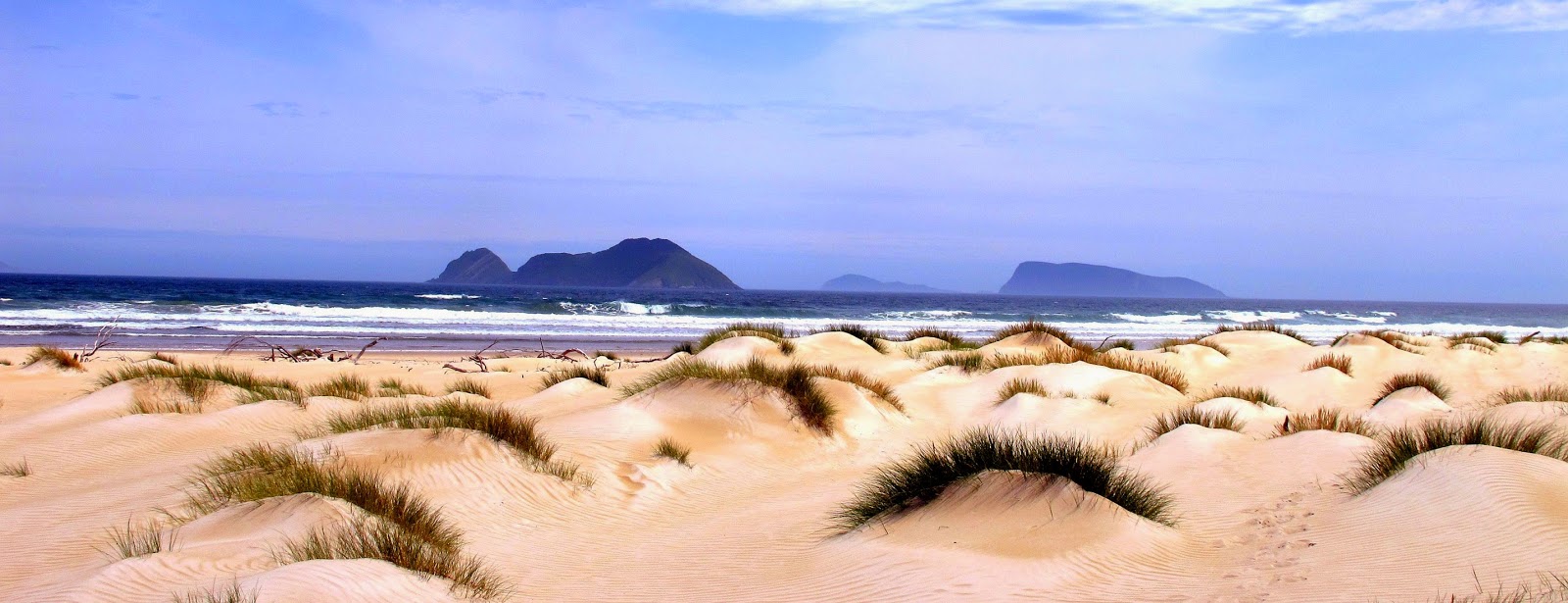
The islands off the South Coast from Prion Beach

Photo: Courtesy of Hugh Maguire and Dan


Precipitous Bluff and New River Lagoon

Photo: Courtesy of Hugh Maguire and Dan


New River Lagoon

Photo: Courtesy of Hugh Maguire and Dan

On the other side the others stopped for lunch - I continued, following the lagoon down to a steeeeep rope-assisted sand dune descent.  But where did the track go then?  No markers beyond that, except for the vague hope of an orange buoy about 500m away near the mouth of the river.  More confusion.  The map was useless, and the book notes were on my camera - which was dead.  After about 30 minutes of trying to find my way, Joe and Nathan caught up.  I decided to give wading around the edge of the lagoon a go, even though it looked really deep.  By fully using my depth stick I was able to make it through, as did the others.  Apparently the location of the river mouth varies greatly over time as the sand bank changes location, hence the vague notes.  But still, another example of Parks Tasmania's selective concern about hiker safety.

Our destination that night was Omiridium Beach.  It was a nice campsite (despite the march flies).  But the beach was just lush.  Beautiful sand, crashing waves and lots of hidden inlets.  

DAY 8

Osmiridium Beach

After a pleasant evening, Steph & company and the others all departed and I stuck around for the day - and what a day it turned out to be! Proper summer :)  And it wasn't even windy.  I had the whole beach to myself.  I sunbaked most of the morning then invented a new martial art in the afternoon - called Buoy Swinging.  I found a well-weighted buoy and used the short rope to swing it around my body - great exercise for the core :)  Later, Jackie & Richard (whom I had met briefly at Louisa River) arrived and we all exchanged our stories of the ups and downs of this magnificent hike.  Richard had brought a mini bottle of champers for Jackie's 50th and cooled it bushie-style... in the creek :)

Honestly, this was one of the best days of my life.

DAY 9

Osmiridium Beach - Surprise Bay

An easy day.  I don't remember much about the walk itself except for the moment when one of my patented mudhole-avoiding leaps went perilously wrong.  I was aiming for the start of a boardwalk to cross a creek but fell just short - my left shin scraped the boardwalk instead.  It wasn't deep but it was extensive, all the way up my shin.  I actually got to use my first-aid kit and completely sealed the wounds by wrapping them in plaster tape.  Which was quite painful to remove, as it brought my leg hair with it.

I arrived in Surprise Bay around lunchtime and snagged the best spot - a camp site with a gorgeous view.  I had read on someone else blog that Surprise Bay was the highlight of their trip - and it didn't disappoint.  A sheltered bay, beautiful creek and rocky outcrops pushing into the surf to create beautiful wading pools.


I think this is Surprise Bay

Photo: Courtesy of Hugh Maguire and Dan

Another great day.  Richard and Jackie arrived later, as did Brendantheadamash and we chatted into the evening.  Ah such bliss :)


Photo: Courtesy of Hugh Maguire and Dan

DAY 10 

Surprise Bay

Another rest day.  I didn't have it to myself all day like I did at Osmiridium, but this was just as divine.  I explored both ends of the bay as far as I could, rock hopping out hanging with the waves and oystercatchers and seaweed.  The water was beautiful of course, but very cold, so a quick dip followed by warming up in the sun.

Hugh & Dan arrive towards the end of the night and they took pity on my no-camera situation.  Hugh offered to share their photos with me and we exchange emails.  So all the photos from the Ironbounds onwards are courtesy of them - thanks very much guys!  Apologies if it appears like I've butchered the originals - I used a lot of 'Auto Fix Lighting' so they might have changed a bit...


Photo: Courtesy of Hugh Maguire and Dan


Photo: Courtesy of Hugh Maguire and Dan

DAY 11

Surprise Bay - South Cape Rivulet

Unfortunately all good things must end, so they say.  And yes I had to say goodbye to Surprise Bay :(

It was quite a hike to South Cape Rivulet.  At the start of the trek this section might have been fairly easy actually, but by this time all the hiking and climbing and epic jumping I had done was starting to catch up with me - I think my body was in wind-down mode after my series of easy and rest days.  I wasn't too happy to have to climb and descend, and yet that is what I had to do.  So I ended up being a bit cranky this day.  I realised my neck and upper back muscles had seriously cramped up, despite my best efforts to give them some relief every day.

Many people had described how hard the South Cape Range was to cross - it was hard, but not as hard as the Ironbounds descent.  It did take quite some time though.  I met and passed several people on the way - I was definitely in 'get it done' mode now... I just wanted to set camp and enjoy my last night out.


Granite Beach - the rocks here are believe it or not, granite.

Photo: Courtesy of Hugh Maguire and Dan

Apart from Granite Beach, one of the highlights of the day was passing a Leatherwood (Eucryphia lucida) tree, source of the famed fragrant honey.  The flower smelt amazing! I've never smelt anything like it, so rich and complex.

Eventually I arrived at the beautiful South Cape Rivulet.  What a place!  With the rest of the afternoon I took some sun and explored the area, including rock-hopping all the way out to the eastern point to look into the next gorgeous bay.  On my way I came across pools full of diverse seaweeds and fish and rock things... sooo cool! I stayed out on the point as the sun went down.  I didn't want this to end.


Photo: Courtesy of Hugh Maguire and Dan

DAY 12

South Cape Rivulet - Cockle Creek - Geeveston - Hobart - Melbourne

At a beach similar to Granite Beach, I searched for and found a suitable massage stone - about 12cm long, fairly thin with a rounded, pointed and thin end.  Don't tell Parks Tasmania please :)


Photo: Courtesy of Hugh Maguire and Dan

The hiking was, as usual, gorgeous.  I realised soon enough though that I needed to step up the pace if I wanted to make the 11.45 am deadline for the bus to Hobart.  I had thought it would be an easy stroll into Cockle Creek.  Everyone had been telling me that it was boardwalked all the way.  It was, once you started to head inland.  But the thing was that there was a lot of beach hiking to do before you got there.

So soon enough I was stepping it out, aiming for around 6 or 7km/hour.  I honestly don't remember much of the countryside, except for the distinctly different vegetation and geography of Moulder's Hill as I came closer to Cockle Creek.  Just as I was arriving (with 20 minutes or so to spare!), I met three very young women (late teens I'd say) heading off to climb Precipitous Bluff, and considering there is no official track, that's quite a challenge!

At Cockle Creek I cleaned myself up and changed into my Sunday best and waited for the bus.  As you can see I made it back to Melbourne that evening, which was a ridiculously fucking epic mission.  But I had some hours in Hobart, including getting a strong latte from Straight Up that would compete with the best in Melbourne, and a fat greasy burger and fries from The Standard as per Hugh & Dan's recommendation.  I also visited the Botanic Gardens, which were small and lovely despite being next to the motorway out of town.

It had been an amazing experience.  When people were asking me how it was, the most I could come up with was 'it was beyond words'.  So that's how it is really.  Beyond words.  

PS But really, don't do the Port Davey track unless you're a sadist :)

Port Davey Track

Port Davey Track

WARNING: if you are considering walking this track, think long and hard about it.  It's very muddy, not very spectacular and quite difficult to navigate at times due to poor track marking or lack thereof.  If I had the chance again I would not walk this track, but instead choose to walk around the South-West Cape near Melaleuca instead.

WARNING: This blog contains a daily selfie (or two).

DAY 1

Launceston - Scott's Peak Dam - Alpha Moraine

I spent Christmas with my sister-in-law Heidi's family in Launceston.  Thanks for a lovely Christmas and the hospitality, John and Margot! :)  Boxing Day morning Mum and I got the hire car and, after a false start where our car exploded somewhat, drove the short length of the state down to Scott's Peak Dam.

After arriving at about 2.30pm and registering at the Port Davey track official start, Mum dropped me off at the dam lookout and I bush-bashed down to the track.  The first section of the track was pretty easy actually - extensive sections of boardwalk in between quartzy sections of track.


After about half an hour or so things started to get pretty shitty.  The section of track between the dam and Junction Creek cops a lot more hiker traffic than the rest of the Port Davey track - as a matter of fact after I left Alpha Moraine the next morning I didn't see a single soul until I got to the airstrip at Melaleuca!

The thing about this part of Tasmania is that the soil type is predominantly peat. Kerry Lyn Bridle did a study on soil of the soils in the area and states 'Peat soils in south west Tasmania are shallow, with an average depth of 30 cm. Three types of peat were recognised: fibrous, intermediate and muck.' 
Well I sure came across a lot of muck. And what wasn't already muck becomes muck as soon as the vegetation is removed. So things soon get pretty epic when that's combined with a lot of rain and water, lots of foot traffic made heavier by heavy packs and boots that weigh a kilo each.

THEME ALERT: LOTS OF MUCKING MUD.

I met about 3 groups of people heading to the Western Arthur Range, a spectacular collection of granite crags over gorgeous lakes that played a starring role in the first day's walking.


I came across a couple of unafraid pademelons in one of the rare patches of forest and also collected a stray thong - it looked like a fresh dropping (I'm officially a hiker scatologist) so I took it with me.  Sure enough, at the Junction Creek crossing I came across its very thankful owner :)

After a strong afternoon push I made it into Alpha Moraine camp at around 9.00pm.  All the official campsites were taken, and I was preparing to set up tent in a very uncomfortable spot next to the creek when I happened across a much nicer spot - phew!  I set my 1-man Kathmandu Mono for the first time, had dinner and settled in for the first night out.  It was great to be out there!

DAY 2

Alpha Moraine - Watershed Camp

I had originally intended to do a quick sprint up to Lake Cygnus and back on this day, but rain started to come in by the time I had packed up, so I thought better of it and set off.  It was very windy, and soon enough the cold sideways rain started.


I was walking straight down the wind tunnel too, so every time I raised my head to see where I was going, the rain stung me in the face.  Soon it was so bad that I found shelter behind a large boulder - I sat there for about 45 minutes until I could re-start.  I wasn't too impressed, but luckily before long the weather improved for the day and I got some relief.

This day was very monotonous walking.  After rounding the Western Arthurs the path turned to the south-west and into a rather challenging-looking valley.  I was reminded of Gimli speaking of the way to Mordor - "Festering, stinking marshlands, far as the eye can see!"  It did look a bit Lord-of-the-Rings-esque.


I crossed a long buttongrass plain interspersed with burnt-out sections of scrub.  I'm not sure when the fire went through here but it was obviously a while ago - the vegetation was taking a long time to recover.  I crossed Crossing River, which was flowing quite well and crystal clear.  One of the best parts of this hike was the quality of the water, and its availability.  Basically everywhere you walked was wet, so soon enough you would pass a creeklet or creek.   The water tasted amazing and just felt so healthy :)

After crossing the Crossing I pushed on to Watershed Camp.  But really, what a boring, wet and muddy day... lucky I was miles from anyone in the middle of wilderness to make up for it!


DAY 3

Watershed Camp - Forest Camp

The Lost World Plateau was what I was looking forward to this day.  While there wasn't much written about it on the internet, I figured if someone had gone to all the trouble of naming it such then surely it has to be cool... right??  Well... let's just say it wasn't quite as spectacular as its namesake from Venezuela, Mt Roraima.  

Actually it was boring as dog shit.  Exactly the same vegetation, topography and views as everything else on this hike.  Why bother naming it anything at all?  But at least the morning was a fine one, good to get out and feel the sun on my face and breathe the fresh air.  You can see the amazing plateau behind me.


The main thing of note from that morning were all the spider webs.  Oddly enough I hadn't come across them in the previous two days, and then after about lunch time they disappeared again.  Bizarre.  


This was another boring day really, except for the confusion around Spring River.  Both the book (South West Tasmania by John Chapman) and the map (South Coast walks) stated that the official campsite is on the east side of the river after the crossing.   However I found an extensive campsite before crossing the river on the west side.  Water access from the river crossing itself which is about 50m to the north.  NOTE: This is a very easy place to get lost.  There was a little pink marking tape leading north from said campsite but I didn't see it, and proceeded to head south into the river jungle and got lost and extremely frustrated for about 30 minutes or so.

The river crossing itself wasn't too bad, but probably might present a challenge for those of us who don't think that they're related to Bear Grylls.  It's currently a log that has broken in the middle to become submerged in the river.  The broken log's branches have placed pressure on the guide rope in places which makes the traverse even harder.  Oh, and stinky ants are using the rope as a highway over the river... and not even paying any tolls!  But if you hold tight to the rope and keep your footing sure you will be fine.

I also didn't find this apparent 'main Spring River campsite' after the crossing that Chapman and the map were referring to...


After leaving the river, I crossed another small feeder creek, then climbed briefly onto a ridgeline where I stayed for the rest of the day.  I ended up at Forest Camp, which was quite a nice spot really - dry, sheltered and clear.  However if you do plan to camp here, it is a 10 minute walk down the track to the rainforest creek to get water.

DAY 4

Forest Camp - Melaleuca

The last weather forecast I had gotten had said that this day would be between 20-40mm of rain... that's a lot!  When I woke up, however, the sun was out.  I packed quickly and got away.  


Soon enough the vegetation and geography returned to 'normal', however this day was more undulating and elevated than the previous ones.  I pushed on through, trying to at least cross the Bathurst Narrows before the rain came.  Before long I got my first ocean views :) You can see the rain threatening from the south.


As much as I bag out this Port Davey track, the views on this section of the walk were spectacular - of Bathurst Harbour, Mt Rugby and the entire surrounding area.  Soon enough I was at the juncture to the Farrell Point forest and campsite.  I dropped my bad and went down to check it out.  What a spot! Best campsite of the track, for sure.  If I'd known it was this good I would have planned to stay a night here... right on the ocean, sheltered and dry.  It was a little difficult to find water but there is a trickle of a creek there.

And so to the boat crossing.  NOTE: If you are reading this thinking of walking the track solo, you have to be quite strong.  I am 6'1, very fit and reasonably strong - yet the job of turning these fiberglass dinghies over all by myself was very challenging.  As was dragging and pushing them all the way up and down the metal guide rails (Joan Point side).  I would estimate the boats weigh about 200kg each (could be wrong but they are damn heavy).

Just as I was eating and drinking and generally preparing to row over the first crossing, it started to rain.  I positioned the boat upside down on the edge of the platform and sat under it - perfect! Soon the shower passed though so I got to get in and row over the Narrows.  It wasn't easy.  The boat wasn't it great condition - one oar lock was missing and the oars were quite worn.  I made it eventually, discovered a de-mountable used by Parks workers and their rubbish (!), and then proceeded to tow the other boat behind me back to the other side.  NOTE: Prospective hikers, remember to take a second set of oars for the second boat with you too! Then left that boat there and returned at last to Joan Point, just as more rain was coming in.  It was nice to taste the ocean, breathe the salty air and to rinse my wounds in salt water.


It was still fairly early in the day, so I set out to see how far I could get before the rain really set in. I saw two white-bellied sea eagles - magnificent! :)  NOTE: After walking along Joan Point the path seems to climb a small hill to an open forest with markers that lead down to a creek and the cove on the west side of Joan Point.  There is a campsite here, but not an official one.  It's probably one used by fishermen or other seafarers, not hikers, as there was lots of flotsam and jetsam around.  In any case this is not the path.  The real path probably doesn't even climb the hill, but the way I got back to it was by re-tracing my steps out of the forest and following a little goat track down the east side to the track.  This part of the track was very overgrown in places, but inexplicably it did have some sections of boardwalk.

After another round of getting lost, the rain decided to come in steadier.  I had at some point discovered that my pack cover (purchased in Santiago de Chile) was not waterproof, so I bunkered down with my tent fly over me and waited out the heavy stuff.  After that finished I set off again... and the rain set in again.  According to Chapman there is a campsite 'in the forest near Horsehoe Inlet some 300m to the west - there are no tracks to the forest'.  Well he got that right, and without tracks, in the rain, it was a difficult task to even get there. So instead I bit the bullet and set out for Melaleuca instead.

I pushed hard to get there - it was a long afternoon.  But being Tasmania in the middle of summer, it doesn't get dark until 10pm so I was able to make it with plenty of daylight left.  It was a bit distressing to see the airstrip and 'eco-tourist' facilities there, but it could have been worse I guess.  There were a few other hikers there, but only one in my hut.  The hut was complete luxury actually.  Out of the wind and rain, benchtops for cooking, mattresses, places to hang clothes and gear to dry and plenty of floor space to stretch on.  I met the volunteer rangers and volunteer bird-watchers, who were lovely.  Chris even offered me to take as much food as I wanted from the donation bin they had - hikers who were finishing at Melaleuca to fly back to Hobart leave their food with them... I got a couple of gourmet delights and some muesli bars.  I'm posing there in front of the original Charles King Memorial Hut Chimney Flue from 1960.  Also note the map of Tassie (P.S. I didn't see anyone else's map of Tassie the whole trip - I did see a pair of boobies though, and I don't mean the feathered variety ;) - pre-Pedder Dam.  The west road finishes at Maydena and Strathgordon doesn't even exist.


Monday, November 15, 2010

Buenos Aires - Auckland - Sydney - Melbourne: 13/11 - 15/11


On the plane we were served a meal at about 330am by a badly dressed and bi-lingual steward, who spoke normally to the Spanish-speakers in Spanish but then to obviously white folk like myself pulled out the most outrageously posh Queen's English accent I've heard in a long time to say, 'Sir, would you care for the beef, or the pasta?'. Bizarre.

Sleep. Wake, Sleep, shit movies, 13 hours across the Pacific, Auckland, up again, cross the Tasman and finally to Sydney. Michelle and I said bye byes; she was heading up to see her family in Brisvegas and I was to stay a night in Sydney before my flight back to Melbourne the following day. I caught the train to Newtown and marvelled at that ultra-clean, ultra-rich and ultra-nice suburb, while trying to avoid being hit by cars on the wrong side of the road and then wondering why they were stopping to let me cross the road at the pedestrian crossings. I made it to my Hospitality Club (like Couchsurfing) connection Jonathan's house inside of which a party was underway to celebrate the annual Newtown Festival and outside of which the Festival itself happened too. I also took a walk down King St, Newtown (otherwise known as The Coolest Place In The World) where I was almost lost without my sunglasses... Man, it's lucky I'm hot and have a wacky hair-cut, otherwise no-one would have taken any notice of me! That evening Jonathan shouted me pizza, we discussed the end of capitalism and I tested out my blog-showing skills - not a bad effort, I think, got through the whole year in about an hour. Thanks for everything, Jon, very generous of you :)

The next morning I set off for the airport and caught the plane back to Melbourne. Everything in that process had gone way too smoothly... surely there shouldve been a breakdown, or a delay, or a roadblock, or a public holiday? But no, everything just (mas o menos) works here... My Mum was waiting for me at the airport! Thanks Mum! x() On the way back to her place in Montmorency I had a chance to reflect on returning to Australia - passing through my mind were thoughts like 'Man I miss chewing coca leaves', 'I'm really going to have to concentrate not to putting my used shit-stained toilet paper into the bathroom waste-paper baskets' and 'Geez, maybe I should become a heroin addict and then I could look kind of gothic/sexy like that girl in the ad'. I was also genuinely scared at our lifestyle and attitude to life. We seem so apathetic towards our consumerism and ourselves, like its the most normal, everyday thing to do what we do and kind of ignore each other at the same time. Kind of sad, really, and quite scary.

So thanks to anyone or everyone who's reading or has read this blog; I know I've rambled somewhat at times but hey, you only go to South America once right? Or maybe twice. Um, anything else to say? .... er... Not really. Bye :)

Puerto Iguazu - Buenos Aires: 04/11 - 13/11


Being Argentina I paid a lot and got a decent bus ride from Puerto Iguazu that evening down to Buenos Aires - a mere 18 hours in a bus. Being hip I got myself to the coolest part of town (San Telmo) as quickly as possible and randomly ran into Tamara and Ilona! We ended up staying at different hostels but caught up along with their countryman Michael again later for bohemian rapsody at a local 'literary cafe' aptly named La Poesia and a much-needed vegetable meal.

I went to a techno club I'd read about on the Interweb called Bahrein, arriving there at around 1230am to a beautifully decorated but basically empty club. The music wasn't great and it was taking a long time to fill up. Not having much cash I wasn't going to buy a drink and I was playing with the idea of leaving until I discovered the downstair section - the place used to be a bank and they had converted the vault into the 'underground' section called Subsuelo.

There the music was much better, and I soon got onto the floor to dance. There I felt old - partly because the average age of the punters was about 20, and partly because my back was so stiff and slow to warm up. But I felt better when I saw the DJ - white, bald and about 45, Sergio Athos (also club owner and Argentinian dance music pioneer) was rocking the house with smooth and sublime tech and crispy rhythms. The floor soon filled up around me and I realised the dancefloor etiquette here is not so polite as in some other places - some people would just come right up to my space and start dancing in it! But a great nights dancing though, all good. Interestingly enough it seems they also have the No Smoking inside rules here but everyone just ignores it and no-one enforces it - $&&^%ers.

I'd decided the photos for my blog for BA were basically going to be of all the great graffiti around San Telmo, so this was my ongoing mission for my week there. My usual city mission of searching out great coffee continued also with some pleasing results - I also realised the rumours of Buenos Aires' women being the most beautiful in South America were true. At one point I sat outside at a cafe in the coolest part of Cooltown next to a table of four young gorgeous women all doing a very good job of looking beautiful without looking liked they'd tried at all. Later that night was the annual Gay Pride march, where mobile floats cranked loud gay anthems like 'When Love Takes Over'. There were of course lots of PDA's, crazy costumes, marijuana and even public nudity. It was a shame though that pretty much every pair of breasts that I saw were fake, whether on transexuals or ladies. It was great to see lots of shiny happy people and a city mas o menos supporting their cause. I had bought a ticket to see a 'big' DJ at supershiny superclub Pacha but decided not to shell out the ridiculous $ to pay for the taxies required to go there at 1am. After super-cheap Bolivia I was quite jaded with expensive and consumptive Buenos Aires.

The next morning I checked out of my arty hostel to an even artier one, The Art Factory, where the Dutchies and I spent a lovely sunny afternoon, then took a basic tango lesson. This also involved watching our smooth instructors strutting their stuff and a stripped down tango band performing great traditional tango music. The next morning I said goodbye to the Dutchies who were off on the 3 hours ferry to Uruguay and settled in for a Melbourne-esque 17 degrees and rain. During my time at The Factory I of course met lots of international folks, like Tara from Ireland, Craig and Angela from Washington, recently arrived for a world tour after 5 years in South Africa as aid workers, Bonny and Tuchi La Flaca de Anana from Colorado, Christoph and Angelique from Switzerland, Jenni from Finland, Brandy from Canada, who along with Wendy and Sara from the States had just spent some time in a Hari Krishna ashram outside of the city. Bonny and I went to the tiny Botanic Gardens in Palermo where the deadliest things were the cactus glasshouse, fresh loquats and nude statues. One morning at the hostel we had a breakfast band.

Michelle had also completed her year-long pilgrimage and was preparing to leave - we were on the same flight back! We drank coffee and cream that she made from coffee that she'd picked, processed and roasted herself at her volunteer stay in Ecuador. It was satisfying that we could catch up in person and hear of all our adventures, there, at the end of all things...

With some other Arty types I went to see La Bomba del Tiempo, a 16-piece orchestrated and multi-cultural percussion band where we danced a little bit. One of my companions was Marty from Perth, an ex progressive DJ who was on a musical pilgrimage north that involved the World Music Conference in Miami and Creamfields in BA that weekend - jealous! I went to visit the new SAE office just down the way in San Telmo where I participated in a Spanish lesson and then, along with members Vincent, Sean and Michael and SAE manager Phil played some racquetball. It's kind of like a cross between tennis and squash, kinda cool but not quite enough running around for me.

On my last evening I went to the famed Desnivel, a busy steak restaurant with delicious meats cooked to order. Along with Marty, Ulysses from Holland, Estefania from Chile and Max from Germany we completed the fulfilled the requirement of all that come to Argentina by quaffing a nice local red while dining on their fine beef. Back at the hostel the evening's live entertainment was muffled by noise sensitive neighbours and we were asked to click as a sign of our appreciation rather than clap. Our next stop was Red Door, a cool bar around the corner where more drinking and glass-smashing was to be had - I saw about 6 smashed in a small room in an hour! One guy managed to make-out with two different girls in the evening. Soon enough it was 5am, and we were thrown to the dogs in the street. But our hostel companion had other ideas. He led us through downtown to a speakeasy: an illicit after-hours venue. A secret knock, a few quick words, open the hobbit-door and in we went. The next few hours in that seedy but kind of uber-cool place were pool and alcohol and being too drunk and talking a lot of shit and laughing with people like Irish pool shark Mick. Finally Jason from England and I stumbled back to the Art Factory and breakfast. Crazy night.

The next day was quite difficult for me - just functioning was hard enough, but I also had to pack and get over to Michelle's hostel from where we were to leave for the train. After sleep finally took over I think I experienced one of the worst hangovers I've ever had. Hot, dry and scratchy, everything was screaming at me and nothing felt anywhere near as good as being horizontal. Urrrrrrrrrrrrrgh. Michelle lent a helping hand to get me through the transfer to the airport process though, where we had a flight at 230am... they sure do like to do things late in Buenos Aires! What a painful process.

Goodbye South America! Lots of love, Tris.